May 6, 2011

Mokulii Island (Chinaman's Hat)

   Mokulii meaning "small island", better known as Chinaman's Hat because of its resemblance of the chinese plantation workers hats back when sugar cane was still being grown and harvested in the past. 
  This would be Bill and I's second kayak adventure of the day. We had just finished kayaking and hiking the mokulua islands. We ate some food and headed out on our last little adventure. I previously hiked Chinaman's Hat with Cencia, my friend, a few months back. I think the distance between Chinaman's Hat and Oahu is about 500 to 600 feet. Not too sure. But it was definitely way shorter than paddling to Mokulua. I'd say it took us a total of 10minutes of paddling to get there.
   Once on the island. Bill and I put up our kayaks and headed counter-clockwise around the island. There was a pretty distinct trail that headed up toward the peak. We headed up a little dirt area, which was slippery for Bill considering he was wearing his water shoes. Anyways, at the top of the dirt hill, we  did some rock climbing for the remainder of the way up. About the last 15feet or so, there is a yellow rope that aided the rest of the climb to the top. Once Chinaman's Hat, we had a great view from Kaneohe Bay to Kaaawa. There were views of Pu'u Ohulehule, Pu'u Kanehoalani, Kualoa Beach Park, Kualoa fish ponds. The view is a must see if you ever get out to the island. So we stayed up on top for about 30 minutes then headed back down. When we got back to the dirt area, Bill did some butt sliding. Safety first. Haha. We got a few prickly's on us but other than that the trip was well worth the view. 


A shot from the kayak.
Mokulii Island (Chinaman's Hat)

Looking towar Kaneohe Bay.

Bill on Mokulii.

Me on the edge.

Mokulua Islands in the background.

Kanehoalani.


The fish ponds and Pu'u Ohulehule in the back.

Geographic marker.


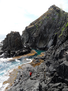
A look off the cliff at the swim area.

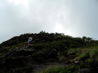
The only roped section at the top.


But sliding is an option when wearing tabes.

Slippery when wet.


May 4, 2011

Mokulua Islands

   On a partly sunny day, Bill and I set out on our adventure to the Mokulua Islands. When we got there the beach was practically empty. So Bill dropped off the kayaks at the beach access and left to park. Its best to get there early because the parking situation is crazy. Im not sure what time we actually started at but it was hot. There was a light breeze so it made it a little more comfortable on the paddle over. About half way there, my arms were burning, and it seemed like we were so far. But i'm pretty sure its 0.75miles to get there one way, but it felt like 50miles. 
  Once we finally got to Moku nui, the larger island of the two, I was so relieved. Bill asked me how the paddle to Chinaman's hat was. And I replied, "not nearly as far." as I gasped for breath and was pouring with sweat. So we sat for a minute and I put on my hiking shoes. I had forgot to mention that to Bill so he ended up just hiking in his tabe's or water shoes. Not the best thing to wear on dry land. 
  We headed out on the northern side, contouring the edge of the island there were lots of holes with Shearwater birds in them. A really neat thing to see. We just had to be carful not to step on any of them. They make a weird humming sound if you get near them. As we got around to the far side of the island. Bill and I didn't expect to see another little island. It was hidden in a little cove-like area. Really neat place. It had a small channel that went around it with a little area that made it good for swimming. But we never went in. We got some pictures in and headed back to the kayaks.
   After we shoved off on our kayaks we took our time and soaked up the beauty of the island. Truly something to experience. Our next stop was Chinaman's Hat. More paddling, yay.

Mokulua Islands. Meaning "two islands".

On the north side of the island.

A look at the islet and mini lagoon.


Bill down below.

A view of Kailua.

Looking toward the Lanikai pill boxes also known
as Ka'iwa.

View of Moku Iki and Waimanalo.


Off the cliffside.

The islet.

Looking on the right of the islet. 

A look to the left of the islet.

Shearwater nesting.

Shearwater.

Moku nui.

Moku iki.

Kaluanui (Mariners Ridge) to Kuliouou

   Mariners Ridge, also known as Kaluanui meaning "the big pit", is one of the shortest and has one of the best summit views of east oahu. So one morning, Tracy, Lacey, Mei, Erika and I set out about 830 on a sunday morning. Partly cloudy, but for the most part pretty clear. I have never done this trail before so I really didn't know what to expect. The hike I planned for us to do was from Kaluanui ( Mariners Ridge) to Kuliouou, meaning "knee sounding"- referring to the hawaiian knee drum). So we parked Meis' truck at the Kuliouou trail head and Erikas' car at the Kaluanui trail head where we began our hike. 
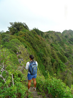
   We started out on a grassy hill heading mauka toward the summit. On the trail, on the right hand side, is a good view of Koko Head and Koko Marina. As we pushed upward we passed through some Ironwood and other various native and non-native plants. The hike is fairly short to the top, about 45min or less. So I really haven't much to say about the trail itself. Except that the higher you get the better the view is. When we finally reached the summit. It was crowded with other hikers. So I suggest getting an early start if possible. Anyways, the view was awsome. We could see from Waimanalo to almost Kualoa, due to a little haze. We took some pictures and caught our breath and headed down a steep hill side toward Kuliouou. I headed down first so I could get some pictures of them coming down. In the process, I've forgotten how much Erika hates steep narrow and somewhat dangerous hikes. I got a few words and "fingers" from her but for the most part she did awsome. So after getting Erika off the hill side, we continued along the ridge. The ridge is pretty well groomed so the hike was very enjoyable. The   whole way to Kuliouou is not too bad. A few roped sections to aide the way, and a few wash out areas. So I just made sure everyone knew to have a good foot hold before attempting the more dangerous sections. When you look at the ridge it looks deceiving, but on the small peaks there are contours around them, so we chose to take the safer path and remain on the main trail. A little after we got up to the first power line, we came upon the Hahaione trail. Its about midway between the two power lines. I almost got confused at that junction, but I remembered that Kuliouou has a giant washout from the rains. When got to the second power line, it has a concrete path that leads up to the poles. Too bad it wasn't in some other areas where it may have better use. After the power lines, we could see the Kuliouou summit trail. I was glad just to know that we were almost there. It took us about 3 hours to do just the ridge line from trail to trail. When we took a look back, it looked more crazy than it really was. Plus if you looked South toward Molokai, we could get a good view to about Maui. 
  After resting up for about 10 minutes. We headed back down the Kuliouou trail. We had a good view of Koko Head, Koko Marina, Diamond Head and Honolulu. Kuliouou is a state trail so it has steps to assist you on the way down. About half way down the trail there is a nice rest area with a little pavilion area nestled within some Cook pine. After the Cook pines, it was all switch backs. And boy was I glad once we hit the road. I was getting flashbacks of Kealia. 
 The trail head at the end of Kaluanui rd.


 About 30minutes and we were there.
 Mariners Ridge.
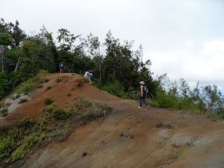
 The first descent

 Nice view from the first little peak.
 A look toward Kaneohe, Olomana and Kailua.
 Waimanalo.


 Lots of eroded areas. 
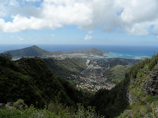
 A look at Koko Crater and Koko Marina.

Diamond Head in the background.


The last push toward Kuliouou.

The view atop Kuliouou. 

Yay, we made it.

The view from Kuliouou.

Cook pine.